功能:
批量转换MODIS地表温度数据(LST)的HDF到GeoTIFF格式
支持多tiles的mosaic
支持剪裁(目前只支持指定矩形范围)
输出指定变量(在LST.prm中指定)
当前版本 1.1 (下载地址见文末)
功能:
批量转换MODIS地表温度数据(LST)的HDF到GeoTIFF格式
支持多tiles的mosaic
支持剪裁(目前只支持指定矩形范围)
输出指定变量(在LST.prm中指定)
当前版本 1.1 (下载地址见文末)
功能:
当前版本 1.02
下载地址见文末。任何问题请向giscn(at)msn.com 报告。 Continue reading
GetMODIS
An effective tool to download MODIS data in a batched manner
批量多线程快速下载MODIS数据的工具
Author: Zhuotong Nan @njnu ([email protected])
Date: 1/18/2016
1. Specifiy parameters in the config.ini file upon your needs
the para names are well self-explanatory.
2. Run GetModis.exe
* Param “tiles” should be set for those datasets tiled such as MOD09GA;
and leave it blank or comment it out for datasets with no tiles such as MOD09CMG
* the format for multiple tiles:
“hTile,vTile”,”hTile,vTile”,”hTile,vTile”…
where hTile represent the horizontal tile no, and vTile the vertical tile no.
* set quietmodel to true if you dont like to see the download progress
* larger number of threads will generally increase the download speed. However too
many threads may cause your ip blocked. a value of no more than 10 is advised.
v1.0 1/18/2016
+ intial release
下载地址:百度云盘(Link)
Source codes are available upon request.
Yu W, Nan Z*, Wang Z, Chen H, Wu T, Zhao L. An Effective Interpolation Method for MODIS Land Surface Temperature on the Qinghai-Tibet Plateau. IEEE Journal of Selected Topics in Applied Earth Observations and Remote Sensing. 2015, 8(9): 4539-4550. DOI:10.1109/JSTARS.2015.2464094.
Links: Baidu;
一种简单有效的MODIS LST内插方法
Zhuotong Nan ([email protected], 南卓铜)
本软件实现了一种新的基于相似性原理的MODIS陆表温度(LST)的插值方法。这种LST数据空间插值方法利用具有相似温度变化特征的已知LST像元集合推算缺失的LST。在青藏高原的案例表明传统的地统计方法基本无法处理大范围连续的数据丢失(比如因为云),而本方法明显优于传统方法,可能较合理的得到缺失LST。此方法尤其适用于大范围山地区域。
This tool implements a new interpolation method for MODIS land surface temperature (LST) following the theory of similarity. It estimates the missing LST pixels by known LST pixel sets which bear similar characteristics of LST variation as the missing pixels. A case study on the Qinghai Tibet plateau has already been carried out, showing its obvious advantages over the traditional geostatistic methods, the latter was unable to do with a large area and temporally continuous data missing situations. This approach is especially good for a study area with a large area and mountainous terrain.

fig 1a, with this approach

fig 1b, with Kriging
我有一个帖子 “MODIS过境时间及相关”描述了modis过境时间的问题。期间收到不少朋友同学的咨询。前些天一个学生在做amsr-e的与气象台站数据对比时,也犯了类似的错误。我再补充说明一下过境时间与北京时间的关系。这个关系,当要对比卫星观测数据和气象台站数据(国内气象台站以北京时计时)时,一定要注意。还是以Terra为例。先举一张过境时间的图。
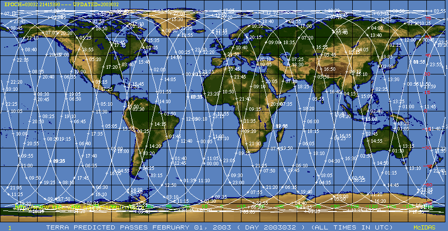
注意terra, aqua都是太阳同步卫星,在固定时间经过赤道(如terra在local time 10:30降轨经过赤道),但千万不要等同于是北京时间10点半经过我们上空。
我注意到一个同学给我的信里讲,terra穿过整个中国也就9分钟,所以如果不需要精确时间的话,可以近似用经过赤道的local time。这里问题主要是出在时区上。
注意我上面帖的图,轨道是斜着的,意味着几分钟后卫星可能进入另一个时区。然而当从境外进入中国,由于中国采用统一的北京时间(utc+8),不管原本应该是哪个时区(local time与这个有关),马上就变成 utc+8了。比如乌市原本应该是在东6时区,卫星经过乌市原本地方时应该是 utc+6,但乌市的气象台站观测是以北京时为准,变为utc+8了。
所以拿过境时间与北京时对比时,就会出现2个多小时的偏差了。
此外,中国陆域面积大,中国区域的数据可能是多次升、降轨合成的,各个地方的过境时间并不一致。
如果需要匹配时间,建议使用数据集里带的时间信息(是以utc标准的),加以自动转换到北京时,然后对比。
[1] Wang Z, Nan Z, Zhao L. The applicability of MODIS Land Surface Temperature Products to simulating the permafrost distribution over the Tibetan Plateau[J]. Journal of Glaciology and Geocryology. 2011, 33(1): 132—143.[王之夏,南卓铜,赵林. MODIS地表温度产品在青藏高原冻土模拟中的适用性评价[J]. 冰川冻土. 2011, 33(1): 132—143.] PDF下载
Zhuotong Nan(南卓铜, [email protected])
教科书上都有MODIS有固定的过境时间,比如Terra说是10am过境(指从北向南经过赤道,中文资料上有意无意忽略这些定语,当地时间),Aqua是13:30过境(从南到北经过赤道。国家MODIS网站上将13:30写成14:30,是错误的。)。其实对于某一区域,过境时间不一样了。比如下面两张NASA Orbit Archive的Terra轨道图。
Aug 2, 2002(左),Dec 8, 2005(右)
对于美国Oklahoma区域(MODIS tile: h09v05)左边在下午5点,右边在下午7点。
而针对16天合成的NDVI和EVI,它是选择其后16天内的观测良好(如无云)的若干观测通过一定算法合成的,每个网格上的数据都有可能来自此16天内的不同时间。幸好NDVI/EVI作为反应植被的一种指标,对半月期变化是可以接受的,用来反应整个植被变化的趋势是足够了。但如果要跟土壤水分等时间性十分强(如一场大降水)的数据耦合到一起应用,则需要慎重的考虑。
(最近看的资料有这些想法,了解不多,如有谬误,请指正)