Category Archives: Work

A document for stream data used in DHSVM

Zhuotong Nan (南卓铜, [email protected])

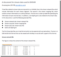
Three files related to stream data are required to run DHSVM. One is the stream network file, which include information for each stream segment. The second is the stream mapping file, which contains stream information on a cell by cell basis. The last one is a look up table file specifying the information of each channel class. In addition, a soil depth grid is also related to the stream data.

In this document, I used the following example files.

  • Stream.network.dat: stream network file
  • Stream.map.dat: stream mapping file
  • Stream.class.dat: stream class file
  • Soild: soil depth grid

The first three data files are in text format which can be opened with any text editors. The last is in ESRI ArcGIS Grid format that can be viewed with ArcMap or any GIS with support of this format.

See the 7-page document for details.

image

pdf, 186KB

Workflow of Preparing Stream Data for DHSVM

Workflow of Preparing Stream Data for DHSVM

Zhuotong Nan (南卓铜, [email protected])

Preparing stream data for DHSVM is very complicated. Many AML scripts as well as Java are involved. Through the example showed below, I want to examine what the preparation really does and what happens behind the scripts. The scripts need ArcGIS workstation, which is not commonly installed. Thus I wrote this article, in the hope that without installation of ArcGIS workstation, you can see clearly the processes and if you want you can re-implement it with other languages.

I created a folder named “highplandpark” on the desktop, whose actual path is c:usersnztdesktophighlandpark. The contents in this folder include,

  • Arcscripts, directory, the aml scripts copied from DHSVM.
  • Programs, directory, the java codes copied from DHSVM
  • Dembuilding_my.asc, file, dem file
  • Mask.asc, file, the mask file for the area of interest

Those files can be found here.

In order to repeat the following steps, ArcGIS Desktop and Workstation, Java Runtime Environment JRE, shall be installed as prerequisites. I used version 10.0 for both ArcGIS Desktop and Workstation and JRE 7. My OS is Windows 7 x64.

image
Generated soil depth grid

Read the 18-page full document, pdf (478KB)

Two attached files

我的2003年工作被IPCC WGI AR4引用

联合国政府间气候变化专家小组(IPCC)第一工作组第4次评估报告是在2007年发布,凭这个报告,IPCC 2007拿了诺贝尔和平奖。该报告引用文献总数达6227篇,其中海外华人文献数目为358篇,大陆作者文献数目88篇,占引用总数的1.41%。其中寒旱所文献13篇,我的地理学报2003年关于西大滩冻土退化的文章也被引用。

BTW,第5次报告应该在2014年发布。

附件是AR4文献引用情况的统计文档,来源于网络,作者未知。

十月份黑河流域中上游考察

本帖文字修改自张凌总结的“黑河流域中上游考察总结”,并补充。

0 考察目的

(1) 了解黑河流域中上游野外观测站点分布位置、站点观测仪器;
(2) 考察黑河流域上游和中游出口水文站;
(3) 考察黑河中游灌溉渠系;
(4) 了解黑河流域分水方案及分水方法;
(5) 了解黑河流域中上游地貌特征;
(6) 了解民勤县生态环境问题。

总共考察6天,2013.10.3-2013.10.8。行程如下:

1. 兰州 -> 西宁 -> 峨堡 -> 阿柔-> 祁连
峨堡、阿柔大寺、阿柔观测点
宿祁连

2. 祁连 -> 冰沟 -> 大冬树垭口 -> 黄藏寺 -> 葫芦沟 ->南山垭口 ->肃南
冰沟径流观测点、冰沟Water试验场、大冬树垭口观测场、黄藏寺黑河交汇处、葫芦沟祁连站
翻走廊南山路差,需要2个半小时。
肃南良友旅游宾馆不错

3. 肃南 -> 高台 -> 正义峡 -> 临泽
高台西路军纪念馆、正义峡水文站

4. 临泽县城 -> 临泽生态站 -> 张掖丹霞 -> 黑水国 -> 张掖
临泽生态站、丹霞地貌、黑水国、张掖甘州市场
荣福宾馆(水务局附近)

5. 张掖 -> 莺落峡 -> 草滩场水利枢纽 -> 遥感站 -> 五星村 -> 张掖
大佛寺、龙首电站、莺落峡水文站

6. 张掖 -> 阿拉善右旗巴丹吉林 -> 雅布赖盐湖 -> 民勤 -> 武威
华信宾馆

7. 武威 -> 雷台 -> 西夏博物馆 -> 天祝 -> 兰州

相关网页:http://blog.sciencenet.cn/blog-922140-734229.html

批量下载气象局的气象数据

批量下载中国气象局的气象数据

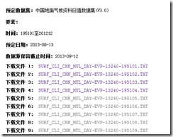
该站密码保护,登陆进去后,一个数据集可能有很多文件,比如中国地面气候资料日值数据集 v3.0有5952条文件。挨个下载十分累。

借用wget可以较容易实现批量下载。

1. 搜索 wget for windows,下载最新版,注意其bin和dep 都是需要下载的,否则bin不能运行。

2. 登陆进去找到要下载的数据集,比如前面提到的日值地面气候资料。如图。

Image(1)

3. 从中得到下载地址和文件名。形成一个files.txt文件。每行格式是<下载地址><空格><文件名>。

tips,可以使用比如notepad++的replace功能,很容易把不要的内容去掉,保留需要的内容。

4. 新建一个wget1.bat 文件。内容是,

@echo off
.wget-1.11.4-1-binbinwget –post-data="userid=<你的用户名>&password=<你的密码>" –save-cookies=cookie_wget –keep-session-cookies "http://cdc.cma.gov.cn/login.do"
for /F "tokens=1*" %%i in (files.txt) do (
.wget-1.11.4-1-binbinwget –load-cookies=cookie_wget -c %%i -O %%j
)

请注意wget的路径,和 files.txt的路径。如果路径不一致,请对应修改。

第一句是保存合适的cookies,第二句是从files.txt里逐句读取,并通过 wget下载重命名。

5. 在命令行下运行 wget1.bat即可。

Image