Category Archives: Work

我们关于MODIS LST 云污染插值的工作

MODIS LST提供了全球覆盖、免费使用的一天四次的遥感温度观测。遥感温度对冻土研究尤其有用,是因为冻土观测站点十分少,如果能够建立观测站点温度(比如0cm地温)与LST之间的关系,那么有望得到区域的温度数据,很多区域冻土研究就可以开展。但MODIS LST存在严重云污染导致的数据丢失,而且这种丢失往往是大范围长时序的连续丢失。这使得传统的地统计方法很难被用于MODIS LST的有效插值。

我们从2011年开始思考MODIS LST缺失数据的插值问题。一种较好的思路是利用微波遥感得到的不受云影响的但空间分辨率很粗的温度数据,里面的难点是如何有效融合高空间分辨率的MODIS LST与粗分辨率的微波遥感温度,已经有很多这方面的研究工作,但目前好像没有特别有效的方法。与这个思路类似的是利用一些模型参与生成的再分析温度数据,也存在分辨率很粗,而且误差较大,存在同样有效融合的问题。

Continue reading

同一门课程多班教学的成绩调整方法

一般讲小班教学(20-30人)效果比较好。但是,如果同一门课程分为几个小班,由不同老师授课,就会经常出现一个问题,即如何让各个小班成绩具有可比性。这是一个非常现实的问题,不同老师有不同的教学风格,尤其是在主观题评价方面,有老师严格有老师相对宽松。但学生们最终的综测成绩时并不区分这些差别,而是直接进行排名。拿到一个公平的成绩是学生们很关心的事情。

为了解决这个问题,我们采用一个曲线调整(Curve)的方法。通过强制不同小班的中位数(Median)保持一致,对每位同学的分数进行非线性调整,从而使不同班级分数具有可比性。这也是很多标准化教学采用的方法(当然可能使用的公式不同)。

Continue reading

我们利用数值模拟方法研究季节变暖和温湿变化对青藏高原冻土热响应的系列工作

背景是青藏高原在近几十年有明显的气候变化,气温在升高,降水在2000年后也有较大增加。而气温的升高具有季节性,冷季的升温比暖季更大。而青藏高原土壤里有大量的冻土存在,这些气候要素的变化影响到了下伏冻土的热状况。所谓冻土是土壤里有冰,冰融化变成水就流出来,青藏高原三江源是重要河流的源头(长江、黄河、澜沧江)。同时冻土的变化也会反馈到气候,冻土融化也可能释放出有机碳等温室气体。

因此,我们针对的科学问题便很有意思,a 冬季和夏季气温升高如何改变冻土热状况?b 从定量角度,冬季气温升高对冻土热指标的贡献是多少?c 在气温、降水同时变化的情况下,升温和增温对冻土热状况的影响分别是多少。

Continue reading

下载GAME/TIBET数据

GAME/TIBET是中日合作的陆气相互作用研究项目,在青藏公路沿线布设了一些站点进行相关项目(如自动气象站、地面辐射、降水、径流、土壤温度/湿度、卫星同步观测、探空等)的观测。时间跨度大概是1997-1998,先进行了第一阶段的观测(POP),然后开展加密观测(IOP)。国内能获取数据的地方大概是寒旱区科学数据中心(http://westdc.westgis.ac.cn)或者WDCD冰川冻土中心,后者其实是前者的英文版本。但目前两者数据服务器不大稳定。
另一个可能获取其数据的地方是DIAS的GAME/Tibet数据中心,由日方负责人Koike
Toshio教授团队维护,网址是http://search.diasjp.net/en/dataset/GAME_Tibet,有完善的文档记录,如果对GAME-TIBET观测项目不清楚的话,可以进去看。
Image[4]

Continue reading

Noah LSM 3.4.1 binaries for Windows

在Windows 10下利用MinGW编译了Noah LSM 3.4.1。可执行包链接如下:

noahlsm-v3.4.1-ming32.zip (Baidu Pan)

包括 driver.exe 对应simple driver版本,urban_driver.exe对应 urban版本。

提供的可执行文件去掉了NetCDF的支持。

更多细节我已经备注到压缩包里的README-more.txt。

MD5码:

8ee77bc180d1a9228212a7485ff17797  noahlsm-v3.4.1-mingw32.zip

README-more.txt

Notice

This is a Noah LSM 3.4.1 version for Windows, compiled with the latest MinGW version (GNU Fortran 6.3.0). I have tested on my Win10 laptop.

NetCDF support has been removed in this binary version due to its huge time costs in compiling with MinGW. You can use ASCII formart to prepare the model drives as demonstrated in the official example data files (bondville.dat). If you prefer to use NetCDF, you have to compile the sources obtained from the offical web site (Goolging Noah LSM).

Credits please go to the group who developed Noh LSM.

Enjoy your research

2018暑假祁连八宝河—青藏高原野外实践(7/13-7/23/2018)

前期准备

购买保险、常用药品;租车事宜;地形图或下载好离线卫星图;行车路线、住宿预定等事宜。

Day 1,南京——兰州,高铁

租借和购买野外所需仪器和材料;

Day 2,兰州——张掖,高铁,宿张掖

火车上午抵达,下午参观中科院黑河遥感试验站

Day 3,张掖——龙首电站——莺落峡——草滩庄水利枢纽——祁连,宿祁连

龙首电站,讲解水力发电及潜在影响;

莺落峡水库对莺落峡水文站观测结果的影响,讲解径流还原的必要性;

黑河干流莺落峡出来后,部分分流到干渠,其余通过自然河流向下,讲解黑河流域干、支、斗、毛到田间的分级渠系结构,讲解黑河分水方案;

草滩庄水利枢纽对自然河道进一步进行控制,至此分解为东西子渠;

莺落峡水文站、草滩庄水利枢纽结合Google地图的卫星照片可以找到;百度地图缺卫星照

至祁连路上经峨堡、阿柔大寺,可停留。 Continue reading

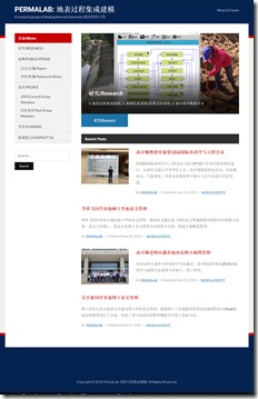
团队官网上线

基于Wordpress,在小内存的VPS上搭了一个团队官网(http://PermaLab.nanzt.info),然后花了点时间选了一个合适的模板,前后大概花了一个周末时间。基本内容都有了,想着把这个学期的工作回溯补充进去。我起名叫PermaLab,一方面工作的一大部分是关于多年冻土(Permafrost),所以我们这个团队就是多年冻土的一个研究团队(Lab)。另一个Perma也是Permanent前部分,希望小队伍可以长久壮大,扎根在这些很挑战的领域。这个新网站作为团队整体工作的一个对外口子。后期想着把一些我们工作介绍出来,把一些产生的数据和代码共享出来。

group-website-screenshot-180624

一种简单有效的MODIS LST内插方法

一种简单有效的MODIS LST内插方法

Zhuotong Nan ([email protected], 南卓铜)

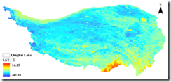
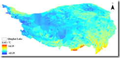
本软件实现了一种新的基于相似性原理的MODIS陆表温度(LST)的插值方法。这种LST数据空间插值方法利用具有相似温度变化特征的已知LST像元集合推算缺失的LST。在青藏高原的案例表明传统的地统计方法基本无法处理大范围连续的数据丢失(比如因为云),而本方法明显优于传统方法,可能较合理的得到缺失LST。此方法尤其适用于大范围山地区域。

This tool implements a new interpolation method for MODIS land surface temperature (LST) following the theory of similarity. It estimates the missing LST pixels by known LST pixel sets which bear similar characteristics of LST variation as the missing pixels. A case study on the Qinghai Tibet plateau has already been carried out, showing its obvious advantages over the traditional geostatistic methods, the latter was unable to do with a large area and temporally continuous data missing situations. This approach is especially good for a study area with a large area and mountainous terrain.

6704d1efb515c7a26d93914d72b14448

fig 1a, with this approach

315bdc690406652281a46f305a2e6697

fig 1b, with Kriging

Continue reading

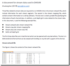
A document for stream data used in DHSVM

Zhuotong Nan (南卓铜, [email protected])

Three files related to stream data are required to run DHSVM. One is the stream network file, which include information for each stream segment. The second is the stream mapping file, which contains stream information on a cell by cell basis. The last one is a look up table file specifying the information of each channel class. In addition, a soil depth grid is also related to the stream data.

In this document, I used the following example files.

  • Stream.network.dat: stream network file
  • Stream.map.dat: stream mapping file
  • Stream.class.dat: stream class file
  • Soild: soil depth grid

The first three data files are in text format which can be opened with any text editors. The last is in ESRI ArcGIS Grid format that can be viewed with ArcMap or any GIS with support of this format.

See the 7-page document for details.

image

pdf, 186KB

Workflow of Preparing Stream Data for DHSVM

Workflow of Preparing Stream Data for DHSVM

Zhuotong Nan (南卓铜, [email protected])

Preparing stream data for DHSVM is very complicated. Many AML scripts as well as Java are involved. Through the example showed below, I want to examine what the preparation really does and what happens behind the scripts. The scripts need ArcGIS workstation, which is not commonly installed. Thus I wrote this article, in the hope that without installation of ArcGIS workstation, you can see clearly the processes and if you want you can re-implement it with other languages.

I created a folder named “highplandpark” on the desktop, whose actual path is c:usersnztdesktophighlandpark. The contents in this folder include,

  • Arcscripts, directory, the aml scripts copied from DHSVM.
  • Programs, directory, the java codes copied from DHSVM
  • Dembuilding_my.asc, file, dem file
  • Mask.asc, file, the mask file for the area of interest

Those files can be found here.

In order to repeat the following steps, ArcGIS Desktop and Workstation, Java Runtime Environment JRE, shall be installed as prerequisites. I used version 10.0 for both ArcGIS Desktop and Workstation and JRE 7. My OS is Windows 7 x64.

image
Generated soil depth grid

Read the 18-page full document, pdf (478KB)

Two attached files